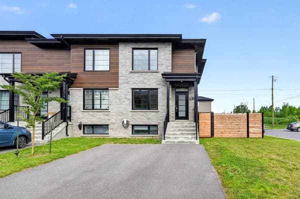
$499,000
38 Rue Morell #12
Beauharnois
2 beds1 bath1301 ft²

Off-Island
A Lac Saint-Louis and Beauharnois Canal city made up of the historic core, Maple Grove and Melocheville, with housing from several eras.
A Lac Saint-Louis and Beauharnois Canal city made up of the historic core, Maple Grove and Melocheville, with housing from several eras.
Highways 30 and 132 support driving, while exo Sud-Ouest lines 1 and 20 provide public-transit options; verify current schedules.
Confirm eligibility, programs, transportation and current boundaries with the CSS de la Vallée-des-Tisserands or New Frontiers School Board.
The regional trail corridor, Lac Saint-Louis shoreline, Beauharnois Canal and Pointe-du-Buisson, subject to current access and water conditions.
Beauharnois is a city on the south shore of Lac Saint-Louis and the Beauharnois Canal. Its municipal territory includes the historic core as well as the Maple Grove and Melocheville sectors, which differ in housing age, street pattern, shoreline setting and distance from services. A search should compare those sectors and then the specific property.
Housing includes older homes near the core, postwar bungalows and other established properties, plus newer subdivisions and condominium or townhouse projects in some areas. New and resale homes require different checks: construction warranty and project documents for recent builds; structure, systems, renovations and permits for older properties. Current comparable sales are more reliable than a general claim about affordability or future appreciation.
Highway 30 and Route 132 are the principal regional road links. Travel toward Montréal, the South Shore or Salaberry-de-Valleyfield depends on the exact address, bridge or interchange used, weather, construction and congestion. Beauharnois does not have commuter rail, so map the complete routine and consult current public-transit options where relevant.
French public schools are administered by the Centre de services scolaire de la Vallée-des-Tisserands, while English public schooling is associated with the New Frontiers School Board, subject to eligibility and boundaries. Confirm programs, transportation and assignment directly with the applicable organization.
The Beauharnois generating station and canal, the regional trail corridor, the Lac Saint-Louis shoreline and Pointe-du-Buisson are prominent local features. Access, hours, activities and water conditions can change. Near the lake, canal or other watercourses, review current flood and shoreline mapping, seller declarations, insurance, soil and environmental records, and any Hydro-Québec, municipal or other property-specific constraints.
Official source links checked in August 2026. Listing availability updates automatically.
Jonathan Ehrlick is a Québec-licensed residential real estate broker with eXp Agence immobilière who serves Beauharnois in English and French. Use this page to follow current listings and local context, then get advice tailored to your property, timing and goals.
Compare homes in Beauharnois, understand current competition and keep financing, inspection, conditions and deadlines organized.
Review comparable sales, current competition and your property's condition before choosing a pricing and launch plan for Beauharnois.
For municipal services, school attendance areas, transit schedules and property-assessment records in Beauharnois, consult the official links below. This guide is editorial and general in nature; boundaries, eligibility, schedules and municipal information can change. Official links verified August 26, 2026.
Current transit note
exo Sud-Ouest lines 1 and 20 serve Beauharnois; consult exo for current stops and schedules before relying on a trip.
Local business data powered by Google.